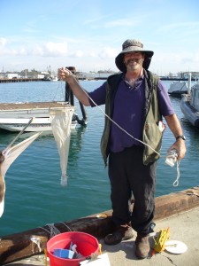
Click on a marker below to learn about the measurements that are taken at each Station. Zoom in and out using the controls on the left, and move the map by clicking and dragging.
Are you a professor?
If so, please click here for directions on planning your trip!
A quick guide to cruise equipment (in order of increasing time commitment):
| Equipment | Purpose | Physical Oceanography/ Water Quality | Oceanography/Geology | Oceanography/Biology | Biology/Ecology |
|---|---|---|---|---|---|
| Pick up to 4/hr | Pick up to 3/hr | Pick up to 3/hr | Pick up to 3/hr | ||
| Refractometer/ Thermometer | Salinity/ temperature | X | |||
| Secchi Disk | Water clarity | X | X | X | X |
| Forele Ule | Water color | X | X | X | X |
| Beaufort Scale/ Sea State | Wind/sea state observations | X | X | ||
| YSI Handheld Electronic Sensor | Tech reads depth, temperature, salinity, pH, dissolved oxygen | X | X | X | X |
| SeaBird 25 CTD ($300 use fee) | High res data via e-mail on depth, temp, salinity, pH, PAR, transmissivity, fluorometer | X | X | X | |
| Vertical Phytoplankton Tow | Phytoplankton | X | X | ||
| Van Veen/Campbell Grab | Mud grab | X | X | ||
| Biological Dredge | Rocks and associated flora and fauna | X | X | X | |
| Horizontal Zooplankton Tow | Zooplankton | X | X | ||
| Dissection/Binocular Microscopes> | Looking at samples, can contribute to seasickness | X | X | ||
| Otter Trawl | Benthic fishes, takes 1 hr, requires collection permit | X | X | ||
| Hook and Line Fishing | Class must bring gear, requires collection permit | X | |||
| Isaacs Kid Midwater Trawl | Class must bring gear, takes 4 hrs, requires collection permit | X |
Station I:
-
- Sediment Station:
- Van Veen Grab:
- Sediment Station:
-
-
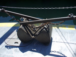
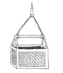
- Van Veen grabs are deployed from the stern (back) of the ship to collect sediment samples from the sea floor. It is important to note the temperature, odor, texture, and color of the sediment samples. For example, odorous samples that smell like rotten eggs are an indication of an oxygen-poor environment and the texture and grain size of the sample can provide clues as to which organisms inhabit the sediment in the area where it was sampled. Most sediments within the harbor are greenish-brown or olive green colors, feel creamy to the touch, and have little to no odor.
-
Station II:
-
- Water:
- Secchi Disk:
- Water:
-
-
-
- A secchi disk is used to determine the turbidity, or clarity, of the water. It is a white disk that is hand-lowered into the water until it is no longer visible. The rope that holds the disk is marked in meters, so that students can determine the “extinction depth” (the depth at which the disk disappears). The disk is lowered one meter more than the extinction depth, then raised until it just comes into view. This depth is also noted, and the depth values are averaged.
-
-
-
-
-
- Turbid waters have high amounts of suspended organic and inorganic matter and have a shallow extinction depth. Alternatively, clearer waters have deeper extinction depths. Turbidity can affect many marine processes, like the photosynthesis of marine plants, or the migration, breeding, and vision of marine mammals.
- Forel Ule Scale:
- Forel Ule scales are used to determine water color. Lower the secchi disk one meter, and match the color on the scale to the color of the disk. The color depends on a variety of factors, like the altitude, the amount of water vapor in the air, or the presence of clouds and dust. Suspended matter within the water can also change the color of the water.
- YSI Handheld Electronic Sensor:
- The YSI Handheld Electronic Sensor is a hand held instrument that displays temperature, depth, salinity, pH, and dissolved oxygen. This can be used up to 82 ft (25 m) depth at no additional cost.
- SeaBird:
-
-
-
-
-
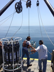
- The SeaBird contains a CTD (Conductivity-Temperature-Depth) sensor, which provides data on the physical properties of the marine environment. These properties include temperature, salinity, conductivity, and percent oxygen saturation at a given depth. The SeaBird is lowered through the water column and records and stores data at every half of a second. This instrument can be used to record data at greater depths than the YSI, but will cost an additional $300 per cruise.
-
-
-
-
-
- The parameters measured by the SeaBird 25 are the following:
-
-
| Depth | Temperature | Salinity | Conductivity | Oxygen % Saturation | pH | |
|---|---|---|---|---|---|---|
| Parameter | meters | T090C | Sal00 | C0uS/cm | OxPS | |
| Normal Range | 9-18 (near shore), < 90 (deep water) | 10-25°C | 33-36‰ | ~500 | 7.5-8.5 |
-
-
- Otter Trawl:
-
-
-
-
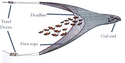
- Otter trawls are used to sample fish that live on or near the bottom of soft sediment habitats. The wide mouth of the net tapers into what is called the “cod end,” and the net is held open by two “otter boards” that are made of wood. The net is lowered from the stern (back) of the boat and is usually towed for 20 minutes at 1.5-2 knots. The animals recovered from the trawl are deposited in the sorting bin on the stern deck for students to observe and identify. At Station II, the fish collected will reside within 9-18 meters (30-60 feet) depth.
Otter Trawls require that the cruise leader (not SCMI) holds a
Scientific Collection Permit. The terms of the SCP require that the permit holder record ALL fish that cross the deck of our vessel, whether or not they are kept. Recording the numbers and species is the responsibility of the permit holder / cruise leader. SCMI can help identify species if needed, and you can use your students to help count. -
-
-
- Plankton Station:
-
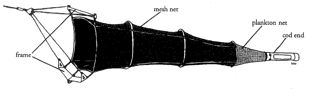
- Plankton nets are used to take sieve (filter) small organisms from the water while a ship is in motion. Net mesh sizes may vary, depending on which organisms researchers wish to target. Two types of samplers exist: qualitative and quantitative. Qualitative samplers focus on the number of organisms in the water without regards to the volume of water that passes through the net. Quantitative samplers measure the volume of water filtered in addition to collecting the organisms in the water column. At Station II, the nets are pulled behind the boat at a speed of 2 knots (2.3 mph) for 5-10 minutes to collect and study the surface-dwelling plankton that are at the base of the food chain.
Station III:
-
- Biological Dredge:
-
-
- Biological dredges sample the substrate and benthic organisms that live on the rock sea floor. The dredge is composed of a heavy, rectangular, metal frame that is approximately 2 feet wide. It is dragged slowly at the bottom for five minutes at the speed of one half knot. The region dredged on R/V Yellowfin cruises is called “The Rock Pile” and is an area on the shelf outside of Los Angeles Harbor where Miocene rocks (12-15 million years old) project through overlying recent and Ice Age sediments. Most pebbles in the Rock Pile are smooth and rounded, due to heavy wave action in historical times.
-
-
- Plankton Station:
-
- are pulled behind the boat at a speed of 2 knots (2.3 mph) for 5-10 minutes to collect and study the surface-dwelling plankton that are at the base of the food chain. The plankton collected are compared to those collected inside the harbor (Station II).
Station IV:
-
- Deep Water Station:
- Secchi Disk:
- Secchi Disks will be used similarly as described for
- Secchi Disk:
- Deep Water Station:
-
-
-
- , and the results will be compared.
- Forel Ule Scale:
- The Forel Ule Scale will be used as described for
-
-
-
-
-
- , and the results will be compared.
- YSI Handheld Electronic Sensor:
- The YSI Handheld Electronic Sensor can also be used as described for
-
-
-
-
-
- , and the results will be compared.
- Seabird:
- The Seabird can also be used as described for
-
-
-
-
- , and the results will be compared.
-
Station V:
-
- White Point Otter Trawl:
- Otter trawls will sample fish and invertebrates living on the sandy sea shore, up to 90 meters deep near the White Point outfall. The results will be compared to those sampled at
- White Point Otter Trawl:
-
- .
Station VI:
-
- Isaacs-Kidd Midwater Trawl:
-
- Isaacs-Kidd midwater trawls will sample the ocean between 200 and 1,000 meters (110-545 fathoms) deep. The trawl is lowered to approximately 550 meters at a location that is two-thirds of the way across the San Pedro Channel and trawled for 1-2 hours. To get to this depth and distance, an IKMT trip needs at least 6 hours. Organisms that reside at this depth are very different from shallower species and have developed interesting adaptations to compensate for the lower light levels of the environment.
- Isaacs Kid Midwater Trawls require that the cruise leader (not SCMI) holds a Scientific Collection Permit (SCP). The terms of the SCP require that the permit holder record ALL fish that cross the deck of our vessel, whether or not they are kept. Recording the numbers and species is the responsibility of the permit holder / cruise leader. SCMI can help identify species if needed, and you can use your students to help count.